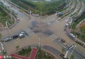
Wen Biya of the 18th typhoon already caused serious disaster in our country this year. According to the data of branch of each district civil administration, up to on August 24, the stricken be hit by a natural adversity and serious area such as Jiangsu Xuzhou, Anhui, Henan, Shandong, Liaoning shares 48 people to die, 4 people are missing, 37 people are injured, collapse / serious damage building 32624, immediate pecuniary loss 25.08 billion yuan. Wen Biya's calamity has exceeded Tian Ge of strong 2017 typhoon (12.1 billion yuan) , and exceeded strong typhoon Mo Landi to comparative roughly 2016, more exceed other 2018 the summation that lands typhonic calamity, already became the our country calamity is the most serious typhoon since 2016.
Up to on August 24 data of the situation of a disaster of Wen Biya part, gas loves a basis in statistic of data of branch of each district civil administration
A the biggest wind-force also is nevertheless when Wen Biya is the strongest the strong tropical storm of 10 class, why is the loss even bigger than the strong typhoon such as Tian Ge? Typhonic calamity depends on many sided element, include air degree of development of landforms of circumfluent, landform, socioeconomy, typhonic intensity is only among them very small on one hand. No less than we what the article pointed out on August 16 is same, below the joint action that is element of a few respects, wen Biya becomes the impact is the biggest typhoon since 2018.
The cloud atlas before the typhoon lands Wen Biya, come from helianthus 8 satellites
1, lunt abundant, energy is enough. Wen Biya is the typhoon that develop by monsoon low pressure and comes, have gigantic type of build or figure, enough steam to supply all the time. Wen Biya lands around, subtropic high pressure holds powerful and prosperous position, lukewarm on the high side of water of the East China Sea, give Wenbiya enough power and heating power support, accordingly it maintains tropical storm intensity to arrive all the time Henan, after landing 4 days still did not disappear. Contrary, columbine build of day of strong 2017 typhoon is very small, lunt is supplied not much, after entering inland very fast abate disappear; Li of Ma of strong 2018 typhoon inferior before landing criterion lunt supplies discontinuity, after entering inland abate those who disappear is even faster than Tian Ge.
Wen Biya enters the pattern that still keeps good after Anhui, intensity and when landing almost same, come from wind and cloud 4 satellites
2, thorough inland, onshore change direction. Wenbiyadeng runs to Henan at a heat after land, ability is subsequently slow turn to go up for north. Come so, all lunt of Wen Biya, energy is taken inland, and be united in wedlock with cold air, cause appropriate of Xuzhou of Henan, Shandong, Jiangsu, Jiangsu to promote the violent rainstorm of and other places and tornado. Under photograph comparing, how to wear than be being stuck all the time with what be strong tropical storm coasting goes, very big one part energy and lunt did not enter inland, influence nature is smaller than Wenbiya much.
Wen Biya and the method that how compare a typhoon are comparative, come from NMC typhoon net. It is Wenbiya inlandly deep
3, was in below the biggest rainstorm the north with a bit weak ability that defend a stand. The biggest rainstorm of Wen Biya appears in Xuzhou of north of Henan, Anhui, Jiangsu and Shandong, these places are the place with relatively weak force of the wind energy that defend a stand, answer typhoon and typhonic rainstorm to do not have sufficient experience, the level of establishment of catchment infrastructure, irrigation works also does not follow to go up. If have the experience defending a stand of southern province, the big calamity the situation of a disaster that believes Shandong birthday light can be reduced a lot of.
18-19 day Shandong is cruel in August pluvial situation
The inspiration that Wen Biya's the situation of a disaster gives us is: The first, cannot judge people with their appearance, cannot take a typhoon with appearance more, weak typhoon causes big disaster likewise possibly, want to combine typhonic intensity, size, method and circumfluent situation, level of progress of society of the landform the general configuration of the earth's surface that combines a typhoon to affect an area, economy and the level that defend a stand considers defense measure integratedly. The 2nd, right circumfluent big, lunt the typhoon with sufficient, thorough and long, inland time, no matter intensity is much,need to take seriously highly greatly. Resemble was in on August 24 92W of double typhoon embryo, 93W, although their intensity compares Wenbiya to want to lose, but lunt abounds degree Biwenbiya is none inferior, also will thorough inland, cause strong precipitation of southern big range. Although the southern ability that defend a stand is a few more ambitious, but landform rugged, a mountainous area population is numerous, still should pay close attention to rainstorm tendercy closely and ready-made.
Typhoon of northwest Pacific Ocean reached typhonic embryo distributinging situation on August 24, gas love is in in wind and cloud is tagged on 4 satellites cloud atlas
South is vigilant! Double typhoon embryo will be thorough inland, rainstorm is sent power shortlyOn August 24, typhonic embryo 92W is in Taiwan western taiwan strait is entered after grinding a day littoral. Suffer its to affect, taiwan island western appear big range is especially big rainstorm, two days accumulate rainfall to already was close to 1000 millimeter greatly most; The helix rain belt of typhonic embryo also toes disembark in Zhejiang, Fujian, the rainstorm with coastal Fujian of short for Zhejiang Province has begun. Nevertheless, suffer typhonic embryo periphery to sink air current influence, hot weather of haze of occurrence ash of and other places of Guangdong bead triangle, Jiangxi, Hunan and cruel is angry.
Meanwhile, typhonic embryo 93W already came to the offing that Zhejiang makes an appointment with 1300 kilometers southeast Ning Bo. According to the computational result with super computer current pattern, embryo of these two typhoons will enter our country south in succession: Among them 92W will land Fujian blessing Qing Dynasty on August 25 around, before landing, strengthen likely for 21 typhoons, do not take formal typhoon registered permanent residence possibly also to be landed with intertropical and low-pressure intensity; 93W will be in around was in Zhejiang on August 27 or Shanghai toes disembark, intensity disturbs for tropics, or low-pressure chamfer.
The gather with European embryonic to double typhoon numerical value is analysed, come from NOAA
Can see, these two storm are very weak, southern wind-force won't be too so big; But, these two storm carried huge amount lunt, and fill in deputy excel in period enter our country, will thorough southern inland stops 3-5 day. Accordingly, their rainstorm is very very can wide, big. Always the typhoon with thorough inland, rich lunt, without giving thought to intensity how many, have the possibility that creates serious rainstorm calamity. The Wen Biya of strong tropical storm that just goes is real case.
Of course, what embryo of these two typhoons affects is to fight a typhoon, fight the south with rainstorm stronger energy, and intensity should lose than Wenbiya, so circumstance may a bit better; These two typhoons are embryonic, can saying is to turn the profit of green jade of strong 2006 tropical storm of edition infirmly this. According to current data, divide Chongqing and north of the Yunnan-Guizhou Plateau, whole the Yangtse River with south metropolis be affected by the rainfall of double typhoon embryo, among them Taiwan southwest ministry, Fujian coastal, Zhejiang is rainstorm littoral the first key, laurel of Hunan another name for Jiangxi Province of 3 provinces area a mountainous area the 2nd key that should be rainstorm, the friend that still asks south especially a mountainous area friend raises vigilance.
The central observatory forecast to typhonic embryo 92W
Nevertheless, embryo of these two typhoons also has a lot of favorable place: Above all, fujian, another name for Guangdong Province east, the hopeful of ravages of a drought of the south in Zhejiang removes; Next, outside dividing Chongqing, southern high temperature also alleviates wear off temporarily. After double typhoon is embryonic, cold air hopeful enters southern weather arena.
Changjiang Delta of intertropical and low-pressure harrass strong rainfall of Hua Nadong north tomorrow endingBe heated takes low-pressure effect, on the weekend two days (25-26 day) strong rainfall of Fujian, Zhejiang lasts, and return and other places of Jiangxi of can thorough inland influence, Hunan, abundant rainwater is helpful for alleviating arid. Additional, area of part of Jilin, Heilongjiang today or still have torrential rain, strong tomorrow rainfall enters end. Below the influence of " of " Su Li and cold air, area of northeast greater part is highest air temperature falls to come forward to 20 ℃ , times feeling is cool.
Tropical depression carries strong rainfall to affect Changjiang Delta Hua Nali to see drought at delay
This morning at 5 o'clock, the center with taiwan strait low-pressure tropics is located in Qing Dynasty of Fujian Province blessing east slants to make an appointment with 85 kilometers south city, near the center the biggest wind-force 7 class (15 meters / second) , central lowest atmospheric pressure is 994 100 handkerchief. Predict, this low pressure will with horary the rate that 10 kilometers influence to slant on the west northward to shift, intensity change is not big, one belt is about to install to be landed littoral to benefit in Fujian smooth pool (14-16 rice / second, 7 class, tropical depression) , after landing, continue to boreal direction slants to move on the west, abate disappear.
On the weekend two days, tropical depression will continue to affect Fujian, Zhejiang, and return can thorough inland, bring strong rainfall to and other places of Jiangxi, Hunan. Central observatory predicts, be heated takes low pressure and effect of intertropical cloud cluster, the partial area of and other places of the south in 3 days of Changjiang Delta, Hua Na will have future to arrive greatly rainstorm, bureau ground has big torrential rain. Among them north of Zhejiang south, Fujian, Guangdong is southwest today and other places of island of ministry, Hainan, Taiwan island has torrential rain, bureau ground big rainstorm (120 millimeter of 100 ~ ) .
In precipitation hit pressure below, predict to rise 3 days today, coastal province begins middle east department to will greet stage by stage on the west drop in temperature, fall can achieve 4 ℃ above mostly, most high temperature is brief fall to be controlled to 30 ℃ , heat is decreased a bit.
But Chongqing criterion high temperature lasts, chongqing is this year the city with the maximum high temperature in city of class of our country provincial capital, up to yesterday, number of high temperature day already had 49 days, in light of current forecast, prospective a week still is the control that casts off high temperature hard, the public still needs to notice to do good sunstroke prevention to drop in temperature the job.
Atmosphere expert reminds, there is a typhoon to land Fujian only merely since this year, and the typhoon that affects Fujian is particularly little also, since causing a month, precipitation slants apparently little, the precipitation that tropical depression brings is abundant, can alleviate Fujian, the atmosphere of Jiangxi, Hunan fights drought case. But situation of Fujian foreland rain is violent, when still needing vigilance weak point strong rainfall, be far from hill body, the attention is safe.
Jilin Heilongjiang still has strong rainfall today typhonic influence will enter end tomorrow
Yesterday by day, " of typhonic " Su Li continues northeast direction is mobile, northeaster rain effect enters phase of at the height of power and splendour. Monitor show, yesterday 5 when up to now day 5 when, heilongjiang south, Jilin is upper heavy rain arrives in appearing with the eastpart part, bureau ground encounters big rainstorm even, resembling is river of Jilin flood dragon 24 hours accumulative total fall exceeds 100 millimeter.
Today, area of part of Jilin, Heilongjiang still has stronger rainfall. Tomorrow, northeast strong rainfall enters end. Nevertheless, suffer air of changes in temperature to hand in collect action, the rainfall of northwest area the eastpart part will increase somewhat.
Central observatory predicts, the partial area of and other places of southwest ministry of basin of the eastpart part of north of northeast today area, China north north, Gansu Province, Sichuan has in to heavy rain, bureau ground rainstorm or big rainstorm; Afore-mentioned partial area companion have short when strong precipitation (hour rainfall 20 ~ 50 millimeter, can amount to 60 millimeter above most) , bureau ground has the strong convection weather such as thunderstorm gale. Need the calamity such as the mountain torrents that strong convection of ground of standoff of vigilant stronger rainfall may cause, mud-rock flow.
In typhoon and cold air collective influence falls, yesterday, greater part area greets northeast to drop in temperature, especially the eastpart part of ministry of Jilin Chinese and Western, Heilongjiang and south fall achieve 4-7 ℃ , highest air temperature falls to fluctuate to 20 ℃ , apparent on the low side at all the year round the normal level of the corresponding period. It is with Changchun exemple, 23 days of highest air temperature still have 25.4 ℃ , dropped to 20 ℃ directly yesterday. Drop in temperature today centre of gravity can transfer Heilongjiang, harbin is highest air temperature will drop 3 ℃ left and right sides. Did not come 7 days, northeast air temperature will be fluctuant pick up, but in highest air temperature still maintains upper zone to fluctuate in 25 ℃ , weather is delightful.
Northwest area air temperature also drops one after another, resembling is Gansu Province western, Qinghai is upper yesterday fall achieve 4-8 ℃ . Today, south of Qinghai the eastpart part, Gansu Province will become the focus that drop in temperature, fall can amount to 4-6 ℃ , it is with Lanzhou exemple, the highest air temperature yesterday is 30 ℃ , fall directly today to 23 ℃ , a lot of drop in temperature the place with great strength is highest air temperature can fall to fluctuate to 20 ℃ .
Nevertheless, brief after dropping in temperature, air temperature can return to normal level quickly again around, resembling is Lanzhou will pick up again tomorrow to 29 ℃ , subsequently a few days of metropolises maintain fluctuate in 30 ℃ . But the lowermost air temperature of morning and evening has 17-18 ℃ only, difference in temperature is bigger, public time period of time wants heat preservation.